

Table of Contents
Introduction:
With the increasing population in places like metropolitan cities, the problem of transportation services has increased. The nonavailability of information about buses arrival schedule GPS is used as a positioning device And Zigbee is used as a data transmitting media wirelessly. This system proposes a solution for improving the security provided by transport management by using GPS and Zigbee integration. The system mainly consists of two modules. Vehicle module and Caretaker module here the satellite will send the Latitude and Longitude of the location.
The purpose of the project is to know the location of the School Buses or Company cabs with the GPS and send information to the center via Zigbee. In this process, if the vehicle changes the usual way, the information will be given to the caretaker via Zigbee and the caretaker can lock the vehicle.
This Project presents an automotive localization system using GPS and Zigbee services. The system permits the localization of the automobile and transmitting the position to the owner via Zigbee. The system can be interconnected with the vehicle alarm system and alert the owner in his place. This tracking system is composed of a GPS receiver, an ARM controller, and a Zigbee module. GPS Receiver gets the location information from satellites in the form of latitude and longitude.
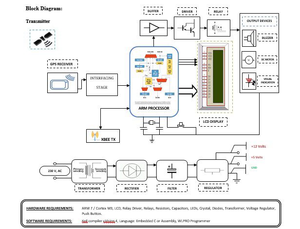
Block Diagram Explanation:
Power supply unit:
This section needs two voltages viz., +12 V & +5 V, as working voltages. Hence specially designed power supply is constructed to get regulated power supplies.
GPS module:
This is a GPS Receiver (5V Serial) with high gain having 4 Pin 2.54mm pitch strip. The third-generation POT (Patch Antenna on Top) is used by the receiver for the GPS module. It can be interfaced with normal 5V ARM7 with the help of the in-built 3V-5V converter. The interfacing is made easier with the help of a low pin count (4-pin) strip. The 4 Pins are 5V, TX, RX, and GND. This standalone 5V GPS Module does not require external components. It consists of an internal RTC Back up battery and can be directly connected to the USART of the ARM7.
The current date, time, longitude, latitude, altitude, speed, and travel direction / heading among other data, are provided by the module and can be used in many applications including navigation, fleet management, tracking systems, mapping, and robotics. The module can support up to 51 channels. The GPS solution enables small form factor devices which deliver major advancements in GPS performance, accuracy, integration, computing power, and flexibility. They are used to simplify the embedded system integration process.
ARM processor:
ARM is a computer processor-based RISC architecture. A RISC-based computer design approach means ARM processors require significantly fewer transistors than typical processors in average computers. This approach reduces costs, heat, and power use. The low power consumption of ARM processors has made them very popular:
The ARM architecture (32-bit) is the most widely used in mobile devices, and the most popular 32-bit one in embedded systems.
Buffers:
Buffers do not affect the logical state of a digital signal (i.e. a logic 1 input results in a logic 1 output whereas logic 0 input results in a logic 0 output). Buffers are normally used to provide extra current drive at the output but can also be used to regularize the logic present at an interface.
Drivers:
This section is used to drive the relay where the output is the complement of input which is applied to the drive but the current will be amplified.
Relays:
It is an electromagnetic device that is used to drive the load connected across the relay and the o/p of the relay can be connected to the controller or load for further processing.
Indicator:
This stage provides a visual indication of which relay is actuated and deactivated, by glowing respective LED or Buzzer.
Methodology:
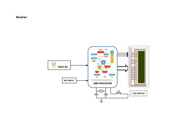
This project is an integration of GPS- Zigbee to enhance the security for School buses or company cabs will be using full to find out the current location of the bus on a particular route for School buses or company cabs. This project contains two embedded system modules one will place inside the vehicle and the other will be placed in charge of the vehicle. The location of the vehicle can be found using GPS and can be sent to the ARM controller via the interfacing stage to check whether it has changed its route or not. If it changed its usual route then the ARM controller will activate a buzzer in the vehicle to indicate to the passengers that it has changed its usual route. If it is moving in the same way, ARM will not activate loads. And all information will be sent to the Caretaker via Zigbee, If the vehicle changes its route at that time that information will be displayed on both the transmitter and receiver display and the Caretaker can lock the vehicle by pressing the switch. GPS Receiver gets the location information from satellites in the form of latitude and longitude and sends the same information to the receiver via Zigbee.
Advantages:
- An automatic way of finding the location of the vehicle.
- Consumes less power.
- Provides very accurate data via GPS.
- Allows the remote location of assets from anywhere there is cellular Service.
- Facilitates simple asset recovery and tracking.
- Helps the visually disabled to navigate safely.
- Information systems in complicated places can be made automatic.
- Improving the capacity of the system helps to cover large areas.
Disadvantages:
- The only thing that is clear about constitutional protections for location-based service information is the lack of clarity.
Applications:
- Public and private transportation.
- Stolen vehicle searching.
- Espionage/surveillance.
- Useful for the visually impaired as an information guide for transportation services.
- Can also be used as a location identifier using suitable modifications.
- Can be used for providing security against theft and enemy alerts for blind people.
- Can be implemented in trains and buses to provide information about the upcoming stations to the passengers.